Home
Agricultural Drought Assessment in Using Vegetation Condition Index (VCI) in Google Earth Engine
Study Hacks-Institute of GIS & Remote Sensing
ไลฟ์สดเมื่อวันที่ 31 ส.ค. 2023
การดู 1,467 ครั้ง
Land surface temperature (LST) monitoring using Landsat imagery in Google Earth Engine
Vegetation Health Index (VHI) for Drought Monitoring using Google Earth Engine
NASA ARSET: Overview of Remote Sensing Observations to Assess Water Quality, Part 1/3
NASA ARSET: Land Cover Classification and Accuracy Assessment in Google Earth Engine, Part 2/3
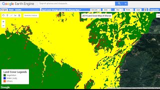
Land Use Land Cover Change (LULCC) between 2001 and 2019 in Google Earth Engine (Study Area: Dharan)
How to Calculate Vegetation Condition Index VCI using #ArcGIS
Supervised Classification for Land Cover Mapping with Landsat 8 in Google Earth Engine
Landsat 8 image classification in google earth engine. Land cover classification in GEE
Rice Mapping using Sentinel 1, 2 in Earth Engine [GEE]
🛑How to make LANDUSE AND LAND COVER CHANGE mapping using Google Earth Engine | LULC change detection
Google Earth Engine: Estimate and map Crop sown area using Sentinel-2 Multi-Temporal data
Google Earth Engine 101: An Introduction for Complete Beginners
NASA ARSET: Google Earth Engine Basics and General Applications, Part 1/3
Identification of agricultural drought extent based on vegetation (health indices of Landsat data)
An Absolute Beginner's Guide to QGIS 3
Sentinel-1/Google Earth Engine Tutorial
Land surface temperature (LST) time series chart using Landsat imagery in #googleearthengine
(1/4) Beginners crash course of Python in Earth Engine for Environmental Insights |Geo for Good 2023
Geo for Good 2022: Time-Series Processing using Google Earth Engine
Download Soil Moisture Data from SMAP using Google Earth Engine


![Rice Mapping using Sentinel 1, 2 in Earth Engine [GEE]](https://i.ytimg.com/vi/We9VoweOuhM/mqdefault.jpg)


